Details
Open year-round, There is no fee to enter the park. Directions:From Redding, drive 65 miles north on Interstate 5. Take the Highway 89/McCloud/Reno exit and drive east on Highway 89. Pass the town of McCloud in nine miles, then continue 4.5 miles further east to a small Forest Service sign for “River Access.” Turn right and follow the signs to the McCloud River Picnic Area and Lower McCloud Falls. (Bear right)
The McCloud Falls are comprised of three levels: lower, middle and upper. Getting to the falls is relatively easy for people of all ages and the hike from the Middle to Upper Falls takes about five minutes. The trails are scenic and offer an opportunity to view various forms of vegetation and wildlife. The falls are different from the other but they are all equally spectacular. There is a picnic area and swimming hole located at the Lower Falls and a cliff for jumping into the McCloud River.
As you are hiking the trail you may see a lot of deer, especially as you through the campground.
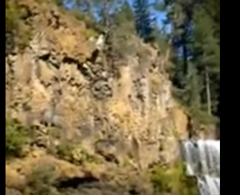
The McCloud River has three falls, all within two river miles of each other and each one giving you something new to see and feel. If you want to swim you will want to be near Lower Falls. This area has the perfect spot for jumpers and divers including a ladder to get out on. Lower Falls is the smallest of the falls dropping just 12 feet. In the spring it is a popular place to spot for kayakers that are taking the trip down the McCloud River.
Middle Falls is wide, powerful and beautiful. This falls drops 50 feet over a cliff and then forms a deep pool at the base. If you want a real challenge as a swimmer this is the area you want to try but make sure you are an expert swimmer, it’s not for the beginner. Photographers love this particular falls and spend lots of time shooting the powerful images. The water ouzels build their homes behind the fall’s tremendous flow of water. These are small stocky diving birds without webbed feet that feed along the bottom of the pool.
The Upper Falls is difficult to view but if you do you will see an exotic-looking narrow funnel of water dropping into a circular turquoise pool. This falls is about 30 feet high. It can be reached in two ways, either by continuing the 3 mile round trup hike form the Lower falls parking area or as a .2 mile round trip from Upper Falls parking area. It is said that they best time to view this falls is from May – October. The elevation is 2,600 ft.
When you are returning to the base you will have an extraordinary view of Mount Shasta. It almost looks like you can reach out and touch it.
Jump Stats
Location
Media
Photos